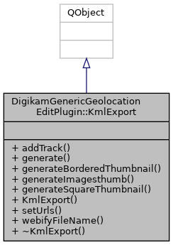
 Inheritance diagram for DigikamGenericGeolocationEditPlugin::KmlExport:
Signals | |
| void | signalProgressChanged (const int currentProgress) |
Public Member Functions | |
| void | addTrack (QDomElement &kmlAlbum) |
| void | generate () |
| QImage | generateBorderedThumbnail (const QImage &fullImage, int size) const |
| Generate a square thumbnail from @fullImage of @size x @size pixels with a white border. More... | |
| void | generateImagesthumb (const QUrl &, QDomElement &kmlAlbum) |
| generate the kml element for pictures with thumbnails More... | |
| QImage | generateSquareThumbnail (const QImage &fullImage, int size) const |
| Generate a square thumbnail from @fullImage of @size x @size pixels. More... | |
| KmlExport (DInfoInterface *const iface) | |
| void | setUrls (const QList< QUrl > &urls) |
| QString | webifyFileName (const QString &fileName) const |
| Produce a web-friendly file name otherwise, while google earth works fine, maps.google.com may not find pictures and thumbnail thank htmlexport. More... | |
| ~KmlExport () override | |
Constructor & Destructor Documentation
◆ KmlExport()
|
explicit |
◆ ~KmlExport()
|
override |
Member Function Documentation
◆ addTrack()
| void DigikamGenericGeolocationEditPlugin::KmlExport::addTrack | ( | QDomElement & | kmlAlbum | ) |
FIXME is there a way to be sure of the location of the icon?
References DigikamGenericGeolocationEditPlugin::GeoDataParser::clear(), DigikamGenericGeolocationEditPlugin::KMLGeoDataParser::CreateTrackLine(), DigikamGenericGeolocationEditPlugin::KMLGeoDataParser::CreateTrackPoints(), DigikamGenericGeolocationEditPlugin::GeoDataParser::loadGPXFile(), and DigikamGenericGeolocationEditPlugin::GeoDataParser::numPoints().
Referenced by generate().
◆ generate()
| void DigikamGenericGeolocationEditPlugin::KmlExport::generate | ( | ) |
References addTrack(), Digikam::DItemInfo::altitude(), generateImagesthumb(), Digikam::MetaEngine::getGPSInfo(), Digikam::DItemInfo::hasGeolocationInfo(), Digikam::DInfoInterface::itemInfo(), Digikam::DItemInfo::latitude(), Digikam::DMetadata::load(), Digikam::DItemInfo::longitude(), Digikam::DItemInfo::name(), and signalProgressChanged().
Referenced by DigikamGenericGeolocationEditPlugin::KmlWidget::slotKMLGenerate().
◆ generateBorderedThumbnail()
| QImage DigikamGenericGeolocationEditPlugin::KmlExport::generateBorderedThumbnail | ( | const QImage & | fullImage, |
| int | size | ||
| ) | const |
Generate a square thumbnail from @fullImage of @size x @size pixels with a white border.
- Parameters
-
fullImage the original image size the size of the thumbnail
- Returns
- the thumbnail
Referenced by generateImagesthumb().
◆ generateImagesthumb()
| void DigikamGenericGeolocationEditPlugin::KmlExport::generateImagesthumb | ( | const QUrl & | imageURL, |
| QDomElement & | kmlAlbum | ||
| ) |
generate the kml element for pictures with thumbnails
- Parameters
-
QUrl the URL of the picture kmlAlbum the album used
we need to take the DateTimeOriginal if we refer to https://www.exif.org/Exif2-2.PDF (standard)DateTime: is The date and time of image creation. In this standard it is the date and time the file was changed DateTimeOriginal: The date and time when the original image data was generated. For a DSC the date and time the picture was taken are recorded. DateTimeDigitized: The date and time when the image was stored as digital data. So for:
- a DSC: the right time is the DateTimeDigitized which is also DateTimeOriginal if the picture has been modified the (standard)DateTime should change.
- a scanned picture, the right time is the DateTimeOriginal which should also be the DateTime the (standard)DateTime should be the same except if the picture is modified
- a panorama created from several pictures, the right time is the DateTimeOriginal (average of DateTimeOriginal actually) The (standard)DateTime is the creation date of the panorama. it's seems the time to take into account is the DateTimeOriginal. but the MetadataProcessor::getItemDateTime() return the (standard)DateTime first MetadataProcessor seems to take Original dateTime first so it should be alright now.
References Digikam::DItemInfo::altitude(), Digikam::DItemInfo::comment(), Digikam::DItemInfo::dateTime(), generateBorderedThumbnail(), generateSquareThumbnail(), Digikam::MetaEngine::getGPSInfo(), Digikam::MetaEngine::getItemDateTime(), Digikam::DItemInfo::hasGeolocationInfo(), DigikamGenericTwitterPlugin::imageFormat(), Digikam::DInfoInterface::itemInfo(), Digikam::DItemInfo::latitude(), Digikam::DMetadata::load(), Digikam::DItemInfo::longitude(), Digikam::DItemInfo::name(), Digikam::DItemInfo::orientation(), Digikam::MetaEngine::rotateExifQImage(), and webifyFileName().
Referenced by generate().
◆ generateSquareThumbnail()
| QImage DigikamGenericGeolocationEditPlugin::KmlExport::generateSquareThumbnail | ( | const QImage & | fullImage, |
| int | size | ||
| ) | const |
Generate a square thumbnail from @fullImage of @size x @size pixels.
- Parameters
-
fullImage the original image size the size of the thumbnail
- Returns
- the thumbnail
Referenced by generateImagesthumb().
◆ setUrls()
| void DigikamGenericGeolocationEditPlugin::KmlExport::setUrls | ( | const QList< QUrl > & | urls | ) |
◆ signalProgressChanged
|
signal |
Referenced by generate().
◆ webifyFileName()
| QString DigikamGenericGeolocationEditPlugin::KmlExport::webifyFileName | ( | const QString & | fileName | ) | const |
Produce a web-friendly file name otherwise, while google earth works fine, maps.google.com may not find pictures and thumbnail thank htmlexport.
- Parameters
-
the filename
- Returns
- the webifyed filename
Referenced by generateImagesthumb().
The documentation for this class was generated from the following files:
- core/dplugins/generic/metadata/geolocationedit/kmlexport/kmlexport.h
- core/dplugins/generic/metadata/geolocationedit/kmlexport/kmlexport.cpp
